 |
|||||||||
|
|
|||||||||
 |
||||||||||
|
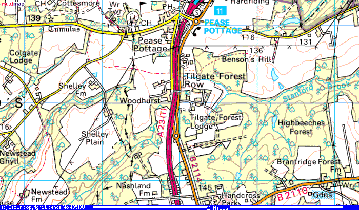
James Muston listed his 'country address' as Tilgate Forest Lodge in a note to family and this shows in the 1891 census. He is listed as being aged 38 living with his wife Martha J aged 35. He is coachman and lives in the Stable House. The map below shows a recent map of the area. Below is a little history and also an interesting story about an archaeological dig on the property.. Photos of the property are included below, at one stage the property covered 5000 acres. |
||||||||||
 |
||||||||||
 |
||||||||||
|
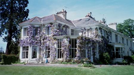
Penny and Richard Mortimore are owners of a part of Tilgate Forest Lodge. Tilgate Forest Lodge (above) is a fairly large country house, now divided into three, we have the south wing shown here. The property is complete with farms, stables, and coach houses. Its past history is therefore reasonably well documented, particularly as the local historian (who has just died aged 90) was born in the flat over the coachhouse. The Nix familys main residence was Tilgate Mansion in Crawley, a few miles away. There a several photo albums running from 1890 to 1920 showing the family at this address. I am afraid therefore we cannot help you, but you are welcome to come and have a look at the house when you are in the UK. Regards Penny Mortimore |
||||||||||
|
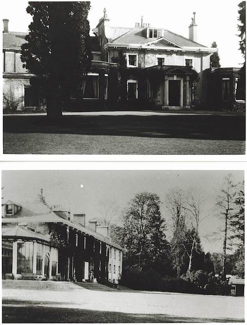
Below are photos of Tilgate Forest Lodge taken in the 1920s sent by Penny. |
||||||||||
 |
||||||||||
|
This is an article I found on the website http://www.msfat.com/tilgate_lodge.htm A Survey at Tilgate Forest Lodge (Found website April 20th 2004) Over two weekends in February and March, we carried out a survey of some earthworks at Tilgate Forest Lodge, between Handcross and Pease Pottage. The earthworks had been discovered whilst clearing woodland, and comprised a series of earthen banks, which could be traced for some distance across the property. We initially carried out a survey of the visible earthworks, planning them onto a map and recording sections across them with a level. They comprised a set of three parallel banks up to a metre high with shallow flanking ditches, running south-west to north-east, which could be traced for about 150 metres through cleared woodland. At the southwest end they could be seen as parch marks on the ground and from an aerial photograph extending for a further 100m, although they did not exist as visible earthworks. Here they appeared to end on meeting an earthwork running east-west, marked as a track on the 1910 OS map. At the north-east end they disappeared in a ploughed field, to reappear in a further piece of woodland, where they were traced as a single bank and ditches for a further 100m. Other banks were recorded running north-west to south-east in this woodland, and could also be traced to the south-east running into another section of woodland. The main set of banks then disappeared again under a grass field to reappear in more woodland. Here they could be traced, as a complete set of three banks and ditches, meeting another track boundary bank, and then running off to the north-east down slope into a stream valley. On the slope the flanking banks peter out, with the central bank continuing down to the stream where it meets other banks running parallel to the stream and appearing to enclose part of the streamside. Other possible earthworks could be seen in the stream valley. Overall the banks could be traced for about one kilometre. A one metre wide section was excavated through one of the banks in an effort to date it and record its profile. It comprised a bank of sandy clay dumped onto the natural soil with shallow flanking ditches on either side. There was no remnant land surface below it. The only find was a single prehistoric flint flake from underneath the bank. The ploughed field mentioned above was fieldwalked during the first weekend. This produced a small quantity of pottery, mostly Medieval and Post Medieval, and some prehistoric flintwork. The flintwork can be dated from the Mesolithic to the Bronze Age, and included a very rare polished barbed and tanged arrowhead. A local collector has picked up microliths, leaf shaped arrowheads and an ordinary barbed and tanged arrowhead, confirming prehistoric activity from the Mesolithic to Early Bronze Age. These earthworks are not easy to date. Old maps dating from 1724 show the whole area to be woodland, which has been progressively cleared in the late 19th and 20th centuries. The field boundary adjacent to the largest set of earthworks respects their alignment so must postdate them, whilst in other areas of now cleared woodland the banks have been removed so must predate the woodland. It therefore seems likely that they could be Medieval boundary ditches. Near the stream, it is possible that the earthworks are part of a water management system possibly associated with ironworking, although we could find no evidence of actual ironworking. Chris Butler. Map http://www.proviser.com/regional/towns/crawley/street_maps/alpha_t.html
|
||||||||||